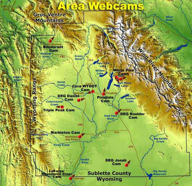
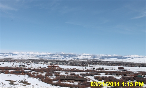
 Pinedale
Web Cam Pinedale
Web Cam
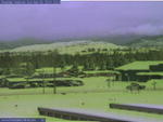
Looking
north over west Pinedale at Wind River Range (currently
out of order)
Camera is mounted
on the Pinedale Entertainment Center building on the west end of Pinedale,
Wyoming looking northeast towards the Wind River Mountains. Building in the
foreground is the Wrangler Cafe. Camera
image updates approximately every 5 minutes. Hourly
image archive on camera page.
Sponsored
by Wolf
Dodge and Pinedale
Online. Maintained by Pinedale Online. Communications by Wyoming.com.
Pinedale
Webcam
Contact: Pinedale Online, 307-360-7689, support@pinedaleonline.com
Images copyright Pinedale Online!
|
 Wyoming
DOT Pinedale US 191 Trappers Point Web Cam Wyoming
DOT Pinedale US 191 Trappers Point Web Cam
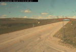
View
looking west along US Highway 191 towards the Wyoming Range
Camera is positioned at the intersection
of Highway 191 and Highway 352 at the Cora/Green River Lakes turnoff. This is
the site of the Trappers Point wildlife bottleneck and staging area for the Green
River Drift cattle drives. Camera
image updates approximately every 5 minutes.
The
camera is provided by the Wyoming Department of Transportation
(WYDOT).
Contact:
Wyoming Department of Transportation, (307) 772-0824 wyoroad@dot.state.wy.us |
Sponsors

Pinedale Online!

Triple Peak

Office Outlet

wyoming.com
BigPiney.com
Sublette.com
Call
or e-mail us to become a
|
WYDOT
US 189 Webcams
Views
looking north and southt on US 189, and a view of the road surface at Sublette
County Fairgrounds north of Marbleton
Camera is mounted on a pole on the southeast corner of the intersection of US
189 and Hwy 351, by the Sublette County Fairgrounds, just north of Marbleton.
This camera set was put in August 2011.
The
camera is provided by the Wyoming Department of Transportation
(WYDOT).
Contact:
Wyoming Department of Transportation, (307) 772-0824 wyoroad@dot.state.wy.us
US
189 North | US 189 South | US 189 Road Surface
  
|
 WYDOT
Hwy 351 Webcam WYDOT
Hwy 351 Webcam
View
looking east on Hwy 351 from US 189 north of Marbleton, Wyoming
Camera is mounted on a pole on the southeast corner of the intersection of
US 189 and Hwy 351, by the Sublette County Fairgrounds, just north of Marbleton.
This camera set was put in August 2011. See previous panel for the other 3
cams at this location which show US 189 north/south/road surface.
The
camera is provided by the Wyoming Department of Transportation
(WYDOT).
Contact:
Wyoming Department of Transportation, (307) 772-0824 wyoroad@dot.state.wy.us
|
 Triple
Peak Web Cam Triple
Peak Web Cam
Looking
west toward Wyoming Range from Triple Peak Lodge in the South Cottonwood
Creek drainage
The
camera is located on the lodge and over looks the fields at Triple Peak Ranch.
Triple Peak Ranch is located 25 miles southwest of Pinedale and 25 miles
northwest by Triple of Big Piney in Western Wyoming. Camera
image updates approximately every 5 minutes through a satellite upload feed. Hourly
image archive on camera page.
Sponsored
by Triple Peak and Pinedale
Online. Maintained by Pinedale Online.
http://www.triplepeak.com/webcam
Contact:
Pinedale Online, 307-360-7689, support@pinedaleonline.com
Images copyright Pinedale Online!
|
SPONSOR
A WEBCAM! JUST $25/MONTH!
Call
or e-mail us to become a sponsor and get your logo and hotlink to your
website from this webcam page.
307-276-5699
or
307-367-6399
E-mail
Webcam Page
Sponsorship
The
webcam pages gets visitation from people from all over the world. Call
or e-mail us for information about becoming a sponsor and getting your
logo and hotlink to your website from this webcam page.
307-276-5699 or 307-367-6399
support@pinedaleonline.com
|
WYDOT
HIGHWAY CAMS
These
cameras are positioned on major Wyoming highways and intersections
to show road conditions for travelers. Images update approximately
every 10 minutes. Wyoming Department of Transportation cameras. More
WYDOT Cams
|
WYDOT
HIGHWAY CAMS
These
cameras are positioned on major Wyoming highways and intersections
to show road conditions for travelers. Images update approximately
every 10 minutes. Wyoming Department of Transportation cameras. More
WYDOT Cams
Evanston Port
of Entry, near Wyoming/Utah state line, facing west.
Rock
Springs On Interstate 80.
Kemmerer Port
of Entry.
Riverton WY
789, southern end of Riverton, looking south.
Lander View
facing northwest.
Alpine
Junction US Hwy 89, view facing east.
Cheyenne Interstate
25 Port of Entry, view looking north.
Cheyenne/Laramie
I-80 Summit looking southeast.
Casper Interstate
25, view looking southeast.
Teton
Pass WYO 22 at top of Teton Pass, looking northwest
South
Pass West and East WYO 28 looking west and east
|
DEQ
AIR QUALITY CAMS
These
cameras are sponsored by the Wyoming Department of Environmental
Quality to monitor air quality conditions due to oil and gas
operations in the Upper Green River Valley.
 DEQ
Daniel Air Quality Cam DEQ
Daniel Air Quality Cam
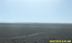
Looking
west at Wyoming Range Mountains from south of Daniel, Wyoming
The
Daniel South air quality monitoring site is located in Sublette County,
approximately 5 miles south of the town of Daniel. This site is expected
to begin operations in July of 2005. This site will include a digtal
camera, ozone analyzer, oxides of nitrogen anylyzer, continuous PM10 monitor and meteorology equipment. Camera image updates
approximately every 15 minutes.
 DEQ
Jonah Air Quality Cam DEQ
Jonah Air Quality Cam
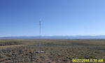
Looking
east at Wind River Mountains from Jonah Field, south
of Boulder and north of Farson, Wyoming.
The
Jonah air quality monitoring site is located in Sublette
County, approximately 40 miles northwest of Farson, approximately
7 miles west of Highway 191. This station began operation
in January of 2005 and is funded by EnCana Oil and Gas
(USA) Inc. A digital camera, ozone analyzer, oxides of
nitrogen analyzer, continuous PM10 monitor
and meteorology equipment are located at this site. In
January 2006, the WDEQ-AQD will assume operation of this
site.
 DEQ-Boulder
Air Quality Cam DEQ-Boulder
Air Quality Cam
Looking
east at Wind River Mountains from Southwest of Daniel, Wyoming
The
Boulder air quality monitoring site is located in Sublette County, approximately
4 miles southeast of the town of Boulder. This station began operation
in February of 2005 and is funded cooperatively by Shell Rocky Mountain
Production and WDEQ-AQD. A digital camera, nephelometer, ozone analyzer,
oxides of nitrogen analyzer, continuous PM10 monitor and meteorology equipment are located at this
site. Camera image updates approximately every 15 minutes.
|
|


