Dollar Lake Fire – Aug. 27 update
Size: 13,449, 10% Contained
by Bridger-Teton National Forest
August 27, 2025
FIRE ACTIVITY:
The Dollar Lake Fire is currently 13,449 acres and 10% containment.
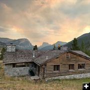
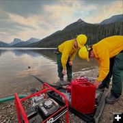
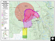
Firefighters are making progress on the west and north sides of the fire, securing more containment line and mopping up. On the south side, Division Oscar and Structure Group South continue to secure the Red Cliff Bible Camp, working directly on the fireline with handcrews and tying the containment line into the road system northeast of the camp and the meadows between Green River Lakes Road and the wilderness boundary. On the northeast side, crews are securing line and mopping up, while on the east side of the fire, handcrews are working directly on the fireline and making their way to the Green River Lake.
Aircraft were not able to fly yesterday, but today’s weather forecast looks more promising. There are currently three Type 1 helicopters, one medium helicopter, and one light helicopter assigned to the Dollar Lake Fire. We also have the use of three scoopers. There is a military medevac helicopter with hoist capability assigned to the fire that was activated by Wyoming Office of Homeland Security through Wyoming State Forestry.
WEATHER:
Wednesday was cool and wet as showers and thunderstorms moved in, resulting in nearly an inch of rain over the fire area. Temperatures peaked in the 50s, with humidity remaining above 70 percent. Monsoonal moisture will persist on Thursday, with continued chances of showers and thunderstorms. However, rain is expected to be more isolated, with lower chances for a wetting rain. Friday and Saturday will see lingering showers and thunderstorms with humidity dropping back down into the 30 to 40 percent range in the afternoon. Gusty outflow winds and lightning remain a threat with any thunderstorm activity.
EVACUATIONS:
Go (Evacuation Order) Status:
A five-mile radius around Dollar Lake in the Green Lakes area.
The Red Cliff Bible Camp in Cora, WY.
Set (Be Prepared to Evacuate) Status:
All residences on Moose Gypsum Road, Hill Road, Valley View Trail, Hecox Road, Pine Drive; Rock Creek Road, Brookie Lane, White Point Road, Rainbow Drive, Trout Drive, Cutthroat Drive, and River Road; Cattle Drive Lane, Terrace Drive, Half-way Drive; all residences off Galley Lane; and all residences along US Hwy 352 South to Richard Lane.
Ready (Monitor) Status:
Areas south of Richard Lane.
For evacuation information please go to:
https://www.facebook.com/SubletteSheriff
CLOSURES:
The Bridger-Teton National Forest has issued a closure order for the Dollar Lake Fire area. Effective immediately, the closure area encompasses the Forest east and south of Green River above its Junction with the Union Pass Road (FS600). Where the Green River exits Green River Lake, the lake shore becomes the boundary along to the south where it meets the Bridger Wilderness boundary. From there it follows the Wilderness boundary south to the South Fork of Gypsum Creek. Then it follows the South Fork of Gypsum Creek southwest to State Highway 352 where the pavement turns to dirt road (Forest Boundary). The area east of the road (FS600 is closed) north, up to the Green River Lakes Road at its junction with Union Pass Road.
Gypsum Creek Road from the Forest boundary north and the network of roads branching off it are in the closure area and not open to the public.
For closure information please go to:
https://www.facebook.com/BridgerTetonNF/ and
https://www.facebook.com/SubletteSheriff
FIRE RESTRICTIONS:
Stage 1 Fire Prohibitions are in effect for the Bridger-Teton National Forest. Fires are not permitted unless they are within a metal or concrete fire pit installed and maintained at a developed recreation site; liquid or gas fuel that can be turned off and no flammable materials within three feet; or a fully enclosed metal stove with a chimney and mesh screen spark arrestor.
For fire restriction information please go to:
https://www.fs.usda.gov/r04/bridger-teton/alerts/stage-1-fire-Restrictions
|


