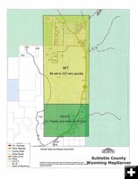

SET for evacuation
New Dollar Lake Fire
evacuation area in SET
status as of Monday, August
25th.
|
|
Dollar Lake Fire update August 25
11,510 acres, 0% containment, No injuries, No structures lost
by Pinedale Online!
August 25, 2025
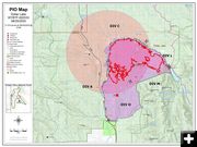
The Dollar Lake Fire is currently 11,510 acres and 0% containment.
Members of the community have created a Dollar Lake Fire help Facebook page here:
https://www.facebook.com/groups/1263431582231003
Additional current information can be found on the Facebook pages for the Bridger-Teton National Forest, Sublette County Sheriff, Sublette County Emergency Management, Kendall Valley Lodge, and the Pinedale Roundup.
COMMUNITY MEETING:
There will be a community meeting about the Dollar Lake Fire on Tuesday, August 26, 2025, at 6:00 p.m. in the Sublette County Public Library in Pinedale.
CLOSURES:
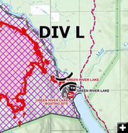
The Bridger-Teton National Forest has issued a closure order for the Dollar Lake Fire area. Effective immediately, the closure area encompasses the Forest east and south of Green River above its Junction with the Union Pass Road (FS600). Where the Green River exits Green River Lake, the lake shore becomes the boundary along to the south where it meets the Bridger Wilderness boundary. From there it follows the Wilderness boundary south to the South Fork of Gypsum Creek. Then it follows the South Fork of Gypsum Creek southwest to State Highway 352 where the pavement turns to dirt road (Forest Boundary). The area east of the road (FS600 is closed) north, up to the Green River Lakes Road at its junction with Union Pass Road.
Gypsum Creek Road from the Forest boundary north and the network of roads branching off it are in the closure area and not open to the public.
For closure information please go to:
https://www.facebook.com/BridgerTetonNF/
and https://www.facebook.com/SubletteSheriff
EVACUATIONS:
Dollar Fire Evacuation update as of Monday, August 25, 3:00PM: Evacuation conditions have been elevated for those near the Dollar Lake Fire in the Kendall Valley area. The Red Cliff Bible Camp and structures on the Bible Camp Road are still in the "GO" Phase – Actively under evacuation. The following residences are being put in the "SET" Phase: All residences on Moose Gypsum Road, Hill Road, Valley View Trail, Hecox Road, Pine Drive; Rock Creek Road, Brookie Lane, White Point Road, Rainbow Drive, Trout Drive, Cutthroat Drive and River Road; Cattle Drive Lane, Terrace Drive, Half-way Drive; all residences off Galley Lane; and all residences along US Hwy 352 South to Richard Lane. Areas South of Richard Lane are now in the "READY" Stage.
For evacuation information please go to:
https://www.facebook.com/SubletteSheriff
FIRE RESTRICTIONS:
Stage 1 Fire Prohibitions are in effect for the Bridger-Teton National Forest. Fires are not permitted unless they are within a metal or concrete fire pit installed and maintained at a developed recreation site; liquid or gas fuel that can be turned off and no flammable materials within three feet; or a fully enclosed metal stove with a chimney and mesh screen spark arrestor. For fire restriction information please go to:
https://www.fs.usda.gov/r04/bridger-teton/alerts/stage-1-fire-restrictions
FIRE ACTIVITY:
The Dollar Lake Fire is currently 11,510 acres and 0% containment.
Despite the fire growth, there have been no injuries reported nor structures lost.
There are now two structure groups for the fire and they have been busy defending numerous sites, including outfitter camps, feed lots, the Red Cliff Bible Camp, and the historic Billy Wells Camp. In addition to the structure groups, firefighters working on the fireline continue to improve containment lines and scout locations for additional containment and contingency lines. Their work is augmented with substantial air support.
Monsoonal moisture continues to increase in the fire area, though it does bring with it the possibility of gusty and erratic outflow winds.
FIRE INFORMATION:
Phone: 307-395-2365
Email: 2025.dollarlake@firenet.gov
Facebook: https://www.facebook.com/BridgerTetonNF
X: https://x.com/BridgerTetonNF
|


