
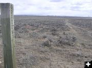
Marked road
In 2009, Pinedale BLM Archaeologists realized that this marked portion of the Lander Road near the New Fork River, and marked as the Lander Trail on all current maps, is actually a side-road, not the original road surveyed by Lander's engineers in 1857 and 1858. Pinedale Online file photo.
|
|
Archaeology meeting in Big Piney on June 15th
Talk on the Wagner Variant of the Lander Trail
by Dawn Ballou, Pinedale Online!
June 9, 2010
The next meeting of the newly-formed Upper Green River Basin Chapter of the Wyoming Archaeology Society will be held on Tuesday, June 15th at the Green River Valley Museum in Big Piney starting at 7:00PM.
Bureau of Land Management Archaeologist, Dave Crowley, will be giving a presentation on the newly discovered "Wagner Variant" of the Lander Trail, which goes through the Pinedale Anticline gas fields. BLM archaeologists discovered the variant route, which is slightly north of the route shown on all current maps, after doing GPS comparisons of the old roads shown on current maps with the survey information on maps made by W.H. Wagner, an engineer who was with Fredrick Lander from 1857-1858 as part of the survey for the central division of the Fort Kearney - South Pass & Honey Lake Wagon Road.
What is now commonly called the Lander Trail was part of a massive effort before the Civil War by the Department of the Interior and Army engineers to identify routes for roads so the west could be "opened." The Lander Trail portion in Sublette County veers from the main Oregon Trail west of South Pass, runs through Buckskin Crossing on the Big Sandy River, then goes west across the desert and through the Pinedale Anticline (just north of Highway 351), crosses the New Fork and Green Rivers, goes through the Big Piney ballfields and the Sublette County Fairgrounds at the junction of US 189 and Highway 351, through the Big Piney airport, then cross-country over into South Piney drainage and up through it into the Wyoming Range mountains, ending at Fort Hall, Idaho.
The variant was discovered in 2009 as part of an effort by the Bureau of Land Management to identify side routes that were taken by immigrants in the 1800s to avoid high waters and find better river crossings and use ferries as part of crossing the desert country segment through what is now Sublette County. By comparing the old survey notes and GPS-ing the old survey records, BLM archaeologists realized that what is being shown on current maps for this segment of the Lander Trail is actually a side trail, not the main surveyed road done at the time Lander and his team marked the road. The significance of the find for management purposes is that federal laws protecting historic trails apply to this new trail segment, which runs smack through the heart of the Pinedale Anticline where gas wells had been permitted and located staying out of the Ľ mile no surface occupancy buffer required for the Lander Trail.
The BLM had allowed gas wells to be located along and near what was thought to be an old two-track road well away from the historic trail. This caused the BLM and gas companies to have to scramble to readjust gas well placement plans to move them away from the newly-recognized Lander Trail segment.
Now BLM archaeologists are in the process of surveying and studying the new trail segment to identify significant cultural resources there. The Upper Green River Chapter of the WAS has been invited by the BLM to help with some of the archaeological survey work on the Wagner Variant. More information on this will be provided at the meeting at the Green River Valley Museum on June 15th. Anyone interested is welcome and encouraged to attend to learn more.
For more information about the Upper Green River Basin Chapter of the Wyoming Archaeology Society, please contact Secretary Betty Gifford at 307-367-5379.
|