
Sage Grouse
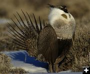
A Greater Sage-Grouse strutting on a lek (breeding ground) in Sublette County. Photo by Cat Urbigkit.
|
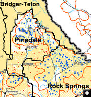
Enlarged Map
The BLM's Preferred Alternative sage
grouse surface disturbance/surface
occupancy restrictions for the Pinedale area.
• Blue dots = areas where surface disturbance is PROHIBITED.
• Red dots = areas where surface disturbance is RESTRICTED.
• Red circles = Priority/Core habitat
areas.
|
|
Sage Grouse EIS released
by Cat Urbigkit, Pinedale Online!
December 29, 2013
The Bureau of Land Management and the Forest Service have released the Draft Environmental Impact Statement (EIS) for the Wyoming Sage-Grouse Resource Management Plan/Land Use Plan Amendments for the Rawlins, Rock Springs, Kemmerer, Pinedale, Casper and Newcastle RMPs; as well as the Thunder Basin National Grassland and Bridger-Teton and Medicine Bow National Forests Land Use Plans. This release opens a 90-day public comment period that will close March 24, 2014.
The Draft Land Use Plan Amendment/Environmental Impact Statement (LUP/DEIS) considers four possible management alternatives for maintaining and increasing habitat for Greater Sage-Grouse on BLM and Bridger-Teton and Medicine Bow National Forest and the Thunder Basin National Grassland in Wyoming. The BLM and the Forest Service have been working closely with cooperating agencies to incorporate local expertise and information. Public involvement in reviewing this draft is the next important step.
Five public comment open house meetings will be held in February to present information on key issues, the planning process and the public comment process. Attendees will learn about the LUP amendment comment process, ask questions, and provide comments in electronic and written formats. Dates and locations will be announced in January.
More than 16 million acres of Wyoming’s Greater Sage-Grouse habitat are on BLM and National Forest System Lands in the project area, encompassing 57% of the entire Greater Sage-Grouse habitat in Wyoming.
The BLM and the Forest Service will issue separate Records of Decision by Sept. 30, 2014.
In March 2010, the U.S. Fish and Wildlife Service determined that listing the Greater Sage-Grouse as a threatened or endangered species was "warranted, but precluded." The FWS determined that current and potential threats to Greater Sage-Grouse habitat and inadequacy of existing regulatory mechanisms pose "a significant threat to the Greater Sage-Grouse now and in the foreseeable future."
The Wyoming Greater Sage-Grouse Draft LUP/EIS is one of 15 separate EISs that are being prepared as part of the BLM’s and the Forest Service’s west-wide national Greater Sage-Grouse planning effort. This effort is being undertaken to provide additional measures to maintain and increase Greater Sage-Grouse habitat on public lands in order to preclude listing the bird.
Information about how to read the entire EIS and the public comment process is provided in the links below. Pinedale Online! did a quick review of the draft EIS and offers this summary of highlights of the Preferred Alternative, as well as specifics to the Pinedale area.
The land surface area of the EIS encompasses nearly 39 million acres of Wyoming, but 15 million of that is private or state ground where the final agency decision will not apply.
The EIS examines a range of alternatives from
A: No Action (continuing current management)
B: Conservation Measures
C: Citizen Group
D: Opportunity w/Protection
E: Preferred Alternative
The Preferred Alternative would emphasize management of sage-grouse seasonal habitat and maintaining habitat connectivity to support population objectives set by the Wyoming Game & Fish Department. A surface disturbance cap of 5% per 640 acres would occur within sage-grouse core habitat.
Inside sage-grouse core habitat areas, the BLM/FS would limit the density of activities related to oil and gas development or to mining activities to no more than an average of 1 location per 640 acres, subject to valid existing rights, and would limit all surface disturbance (any program area) to no more than 5% of the core landscape.
Under Alternative E, the preferred alternative:
• 892,090 acres would be closed to oil and gas leasing (an increase from the current 871,780 acres);
• 689,300 acres would be managed as No Surface Occupancy areas (from the existing 40,980-acre restriction) ; and
• 6,146,570 acres would be managed as Controlled Surface Use areas.
In addition, 304,970 acres would be subject to prohibitions on surface disturbing activities, compared to the current 68,550. The majority of this acreage would be transferred from the "restricted area" status which currently encompasses 437,680, which would drop to about 22,000 acres under the preferred alternative.
Under this alternative, 12,355 BLM/Forest Service oil and gas wells and 2,462 Coal Bed Natural Gas wells would be anticipated in sage-grouse core habitat areas, resulting in 37,380 acres that would experience short-term disturbance, and 8,290 acres that would be disturbed over the long term. The number of wells anticipated would be 10% less than Alternative A (current management).
All core sage-grouse habitat would be closed to wind development.
PINEDALE AREA SPECIFICS:
• Surface occupancy and surface disturbing activities would be prohibited on or within a 0.6 mile radius of the perimeter of occupied sage-grouse leks within the designated sage-grouse core and connectivity habitat areas.
• Surface disturbing and/or disruptive activities would be prohibited within connectivity habitat from March 1 – June 30 to protect breeding, nesting, and early brood-rearing habitats within 4 miles of the lek or lek perimeter of any occupied sage-grouse lek within identified connectivity areas. This timing limitation would be applied throughout the sage-grouse core area habitats.
• Surface disturbing and/or disruptive activities would be prohibited within sage-grouse winter concentration areas from Dec. 1 – March14 throughout the sage-grouse core area habitats.
• The reasonably foreseeable development scenario for federal oil and gas (O&G) and Coalbed Natural Gas Wells (CBNG) for the sage-grouse core/priority areas of the Pinedale region, under the preferred alternative are:
• 154 O&G wells (compare to current management alternative of 447 wells) and
• 18 CBNG wells (compare to 45 wells under current management alternative). The disturbance acres would total 1,950 (compared to 5,610 acres under current management alternative).
• The reasonably foreseeable development scenario for federal oil and gas (O&G) and Coalbed Natural Gas Wells (CBNG) for the sage-grouse general habitat areas of the Pinedale region, under the preferred alternative are:
• 4,263 O&G wells (compared to 4,246 wells under continuation of current management), and;
• 333 CBNG wells (compared to 328 wells under continuation of current management).
• New transmission projects would be allowed within a designated 2-mile wide transmission corridor through sage-grouse core habitat and within 0.5 miles on either side of existing 115 kV or larger transmission lines. Projects in designated corridors and along these routes will not be counted against the 5% disturbance cap. New transmission projects proposed outside of the corridors specified above would be considered where it can be demonstrated that declines in sage-grouse populations could be avoided through project design and/or mitigation.
• Livestock grazing is not considered a surface-disturbing activity, but additional provisions will be added to grazing allotment plans and permit renewals. Incorporating site-specific sage-grouse habitat objectives and management objectives into all BLM and Forest Service grazing allotments, evaluating land health standards achievement in sage-grouse core habitat and, where not achieved, to determine if existing grazing management practices or levels of grazing use on public lands are significant factors in failing to achieve the standards) would be placed on livestock operators, as appropriate, when renewing grazing permits.
• No areas would be identified as closed to livestock grazing, but retirement of grazing privileges would be maintained as an option in core habitat areas where the current permittee is willing to retire grazing on all or a part of an allotment.
To learn more, please look at the links provided below.
|